Minería

Geographic Service (REST)
Thumbnail

Tags
Minería, zonas mineras, Amazonía, RAISG, actividad minera


Summary

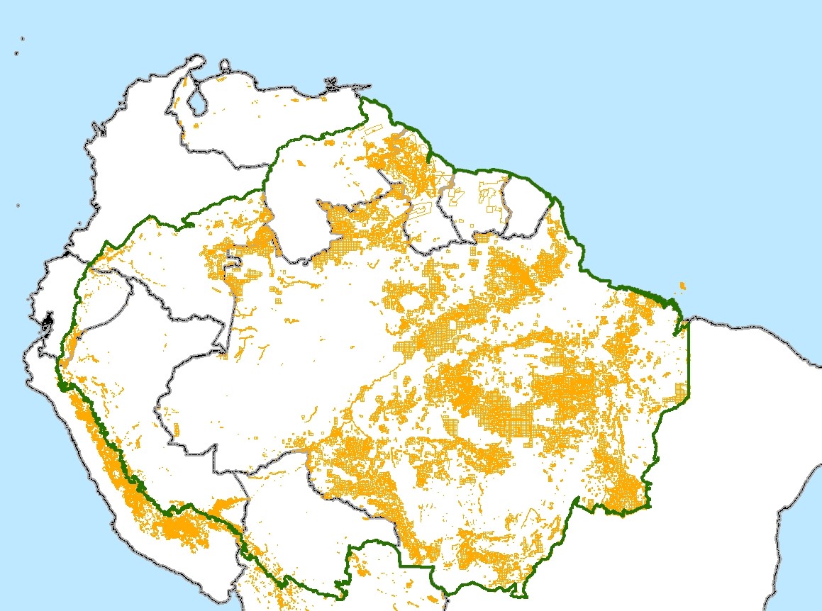
Zonas mineras en la Amazonía

Description

Limites de zonas mineras en la Amazoníay atributos, tais como fase de la actividad (solicitud, en exploración, en explotación, etc.), sustância mineral, companhia responsable, y otros.

Credits

• Bolivia: SERGEOTECMIN 2005; • Brasil:Departamento Nacional da Produção Mineral-DNPM, 2011; • Colômbia: Catastro Minero Colombiano, 2010 (http://www.cmc.gov.co:8080/CmcFrontEnd/consulta/index.cmc); • Ecuador: Ministerio de Recursos Naturales no Renovables, 2010; • Guyana: Guyana Geology and Mines Comission, 2009 • Perú: MINEM, 2011; • Guyana Francesa: • Perú: • Suriname: Natural Resource and Environmental Assesment-NARENA; • Venezuela: Ministerio de Energía y Minas, 2009.

Use limitations

Limitaciones sobre uso de los datos pueden ser consultadas en las instituciones indicadas en la sessión "Credits"

Extent

West -79.576592   East -43.888486
North 11.226013   South -22.879537

Scale Range
Maximum (zoomed in) 1:5,000
Minimum (zoomed out) 1:150,000,000

ArcGIS Metadata 

Topics and Keywords 

Themes or categories of the resource  economy


Content type  Geographic Services
Export to FGDC CSDGM XML format as Resource Description No

Theme keywords  zonas mineras,minería,RAISG

Citation 

Title Minería
Revision date 2015-06-30 00:00:00


Presentation formats* digital map


Citation Contacts 

Responsible party
Individual's name RAISG - Red Amazónica de Información Socioambiental Georreferenciada
Contact's role  point of contact


Resource Details 

Dataset languages  Spanish; Castilian (BRAZIL)
Dataset character set  utf8 - 8 bit UCS Transfer Format


Spatial representation type* vector


*Processing environment Microsoft Windows 7 Version 6.1 (Build 7601) Service Pack 1; Esri ArcGIS 10.1.1.3143


Credits
• Bolivia: SERGEOTECMIN 2005;
• Brasil:Departamento Nacional da Produção Mineral-DNPM, 2011;
• Colômbia: Catastro Minero Colombiano, 2010 (http://www.cmc.gov.co:8080/CmcFrontEnd/consulta/index.cmc);
• Ecuador: Ministerio de Recursos Naturales no Renovables, 2010;
• Guyana: Guyana Geology and Mines Comission, 2009 • Perú: MINEM, 2011;
• Guyana Francesa:
• Perú: 
• Suriname: Natural Resource and Environmental Assesment-NARENA;
• Venezuela: Ministerio de Energía y Minas, 2009.
ArcGIS item properties
*Name bd_raisg.isa.mineria_pl
*Location http://gisserver.socioambiental.org:6080/arcgis/rest/services/raisg/raisg_mineria/MapServer/1
*Access protocol Map service

Extents 

Extent
Geographic extent
Bounding rectangle
Extent type  Extent used for searching
*West longitude -79.576592
*East longitude -43.888486
*North latitude 11.226013
*South latitude -22.879537
*Extent contains the resource Yes

Extent in the item's coordinate system
*West longitude -79.576592
*East longitude -43.888486
*South latitude -22.879537
*North latitude 11.226013
*Extent contains the resource Yes

Resource Points of Contact 

Point of contact
Individual's name RAISG - Red Amazónica de Información Socioambiental Georreferenciada
Contact's role  point of contact


Resource Maintenance 

Resource maintenance
Update frequency  irregular


Resource Constraints 

Constraints
Limitations of use
Limitaciones sobre uso de los datos pueden ser consultadas en las instituciones indicadas en la sessión "Credits"

Spatial Reference 

ArcGIS coordinate system
*Type Geographic
*Geographic coordinate reference GCS_SIRGAS_2000
*Coordinate reference details
Geographic coordinate system
Well-known identifier 4674
X origin -400
Y origin -400
XY scale 999999999.99999988
Z origin -100000
Z scale 10000
M origin -100000
M scale 10000
XY tolerance 8.9831204474460199e-009
Z tolerance 0.001
M tolerance 0.001
High precision true
Left longitude -180
Latest well-known identifier 4674
Well-known text GEOGCS["GCS_SIRGAS_2000",DATUM["D_SIRGAS_2000",SPHEROID["GRS_1980",6378137.0,298.257222101]],PRIMEM["Greenwich",0.0],UNIT["Degree",0.0174532925199433],AUTHORITY["EPSG",4674]]

Reference system identifier
*Value 4674
*Codespace EPSG
*Version 7.11.2


Spatial Data Properties 

Vector
*Level of topology for this dataset  geometry only


Geometric objects
Feature class name bd_raisg.isa.mineria_pl
*Object type  composite
*Object count 87217


ArcGIS Feature Class Properties
Feature class name bd_raisg.isa.mineria_pl
*Feature type Simple
*Geometry type Polygon
*Has topology FALSE
*Feature count 87217
*Spatial index TRUE
*Linear referencing FALSE


Data Quality 

Scope of quality information


Data quality report - Conceptual consistency
Measure description La consistencia de los datos se debe comprobar junto con las instituciones indicadas en la sessión "Credits".


Standard procedure identifier
Value N/D


Evaluation procedure
Title RAISG
Creation date 2015-09-08 00:00:00


Conformance test results
Test passed Yes
Result explanation La consistencia de los datos se debe comprobar junto con las instituciones indicadas en la sessión "Credits".


Product specification
Title RAISG
Creation date 2015-09-08 00:00:00


Lineage 

Lineage statement
Informaciones sobre linaje de los datos se debe pesquisar con las instituciones indicadas en la sessión "Credits".

Distribution 

Distributor
Available format
Name Service
Version ArcGIS Server 10.1


Transfer options
Online source
*Locationhttp://gisserver.socioambiental.org:6080/arcgis/rest/services/raisg/raisg_mineria/MapServer/1
*Access protocol
*Description


Distribution format
Name Geographic Service (REST)
Version ArcGIS Server 10.1


Fields 

Details for object bd_raisg.isa.mineria_pl 
*Type Feature Class
*Row count 87217
Definition
Entity Type
Definition source
ArcGIS


Field OBJECTID
 
*Alias OBJECTID
*Data type OID
*Width 4
*Precision 10
*Scale 0
*Field description
Internal feature number.
*Description source
ESRI
*Description of values Sequential unique whole numbers that are automatically generated.


Field Shape
 
*Alias Shape
*Data type Geometry
*Width 4
*Precision 0
*Scale 0
*Field description
Feature geometry.
*Description source
ESRI
*Description of values Coordinates defining the features.


Field NOMBRE
 
*Alias Nombre
*Data type String
*Width 250
*Precision 0
*Scale 0
Field description
Nombre de la zona minera
Description source
Vide sessión "Credits"
Description of values Nombre de la zona minera


Field cia
 
Alias Companhia
*Data type String
*Width 250
*Precision 0
*Scale 0
Field description
Nombre de la companhia solicitante
Description source
Vide sessión "Credits"
Description of values Nombre de la companhia solicitante


Field situacion
 
*Alias Situación
*Data type String
*Width 50
*Precision 0
*Scale 0
Field description
Situación de la fase de actividad
Description source
Vide sessión "Credits"
Description of values Situación de la fase de actividad


Field tipo_minerio
 
*Alias Tipo Mineria
*Data type String
*Width 50
*Precision 0
*Scale 0
Field description
Tipo de sustancia mineral
Description source
Vide sessión "Credits"
Description of values Tipo de sustancia mineral


Field fuente
 
*Alias Fuente
*Data type String
*Width 100
*Precision 0
*Scale 0
Field description
Fuente de los datos
Description source
Vide sessión "Credits"
Description of values Fuente de los datos


Field institucionraisg
 
*Alias Institución RAISG
*Data type String
*Width 15
*Precision 0
*Scale 0
Field description
Nombre de la institución de RAISG que recibió los datos
Description source
RAISG
Description of values Nombre de la institución de RAISG que recibió los datos


Field fecha_atualizacion_dato
 
*Alias Fecha Atualización Dato
*Data type String
*Width 10
*Precision 0
*Scale 0
Field description
Fecha de atualización de dato
Description source
RAISG
Description of values Fecha de atualización de dato


Field area_sig_ha
 
*Alias Área SIG (ha)
*Data type Double
*Width 8
*Precision 38
*Scale 8
Field description
Área calculada por Sistema de Información Geográfica
Description source
RAISG
Description of values Área calculada por Sistema de Información Geográfica


Field area_oficial_ha
 
*Alias Área (ha)
*Data type Double
*Width 8
*Precision 38
*Scale 8
Field description
Área oficial em hectares
Description source
Vide sessión "Credits"
Description of values Área oficial em hectares


Field leyenda
 
*Alias Leyenda
*Data type String
*Width 50
*Precision 0
*Scale 0
Field description
Leyenda
Description source
RAISG
Coded values
Name of codelist CONCESSIONES_situacion
Source RAISG


Field codigo
 
*Alias Código
*Data type String
*Width 20
*Precision 0
*Scale 0
Field description
Código de la zona minera
Description source
Vide sessión "Credits"
Description of values Código de la zona minera


Field amaz
 
Alias En Amazonía?
*Data type String
*Width 1
*Precision 0
*Scale 0
Field description
Indicación si la zona minera está em Amazonía
Description source
RAISG
Description of values Indicación si la zona minera está em Amazonía


Field globalid
 
*Alias Globalid
*Data type GlobalID
*Width 38
*Precision 0
*Scale 0
Field description
Identificador único de objeto
Description source
SIG
Description of values Identificador único de objeto


Field grupo
 
*Alias grupo
*Data type SmallInteger
*Width 2
*Precision 5
*Scale 0
Field description
Grupo de sustancia
Description source
RAISG
Coded values
Name of codelist MIN_ref_grupo
Source RAISG


Field PAIS
 
*Alias País
*Data type String
*Width 50
*Precision 0
*Scale 0
Field description
Nombre de país
Description source
RAISG
Description of values Nombre de país


Field st_area(shape)
 
*Alias st_area(shape)
*Data type Double
*Width 0
*Precision 0
*Scale 0
Field description
Área calculada por SIG
Description source
SIG
Description of values Área calculada por SIG


Field st_length(shape)
 
*Alias st_length(shape)
*Data type Double
*Width 0
*Precision 0
*Scale 0
Field description
Perímetro calculado por SIG
Description source
SIG
Description of values Perímetro calculado por SIG


Metadata Details 

Metadata language Spanish; Castilian (BRAZIL)
*Metadata character set  utf8 - 8 bit UCS Transfer Format


URI of the data described by the metadata http://gisserver.socioambiental.org:6080/arcgis/rest/services/raisg/raisg_mineria/MapServer


Scope of the data described by the metadata  service
Scope name  map service


*Last update 2015-11-06


ArcGIS metadata properties
Metadata format ArcGIS 1.0
Metadata style ISO 19139 Metadata Implementation Specification
Standard or profile used to edit metadata ISO19139


Created in ArcGIS for the item 2015-07-17 16:06:17
Last modified in ArcGIS for the item 2015-11-06 18:27:07


Automatic updates
Have been performed Yes
Last update 2015-11-06 18:27:07


Metadata Contacts 

Metadata contact
Individual's name RAISG - Red Amazónica de Información Socioambiental Georreferenciada
Contact's role  point of contact


Metadata Maintenance 

Maintenance
Update frequency  irregular


Thumbnail and Enclosures 

Thumbnail
Thumbnail type  JPG

FGDC Metadata (read-only) 

Identification 

Citation
Citation Information
OriginatorREQUIRED: The name of an organization or individual that developed the data set.
Publication DateREQUIRED:  he date when the data set is published or otherwise made available for release.
Title
bd_raisg.isa.mineria
Geospatial Data Presentation Formvector digital data
Online Linkagehttp://gisserver.socioambiental.org:6080/arcgis/rest/services/raisg/raisg_mineria/MapServer/1

Description
Abstract
REQUIRED: A brief narrative summary of the data set.
Purpose
REQUIRED: A summary of the intentions with which the data set was developed.
Time Period of Content
Time Period Information
Single Date/Time
Calendar DateREQUIRED:  he year (and optionally month, or month and day) for which the data set corresponds to the ground.
Currentness Reference
REQUIRED: The basis on which the time period of content information is determined.
Status
ProgressREQUIRED: The state of the data set.
Maintenance and Update FrequencyREQUIRED: The frequency with which changes and additions are made to the data set after the initial data set is completed.

Spatial Domain
Bounding Coordinates
West Bounding CoordinateREQUIRED: Western-most coordinate of the limit of coverage expressed in longitude.
East Bounding CoordinateREQUIRED: Eastern-most coordinate of the limit of coverage expressed in longitude.
North Bounding CoordinateREQUIRED: Northern-most coordinate of the limit of coverage expressed in latitude.
South Bounding CoordinateREQUIRED: Southern-most coordinate of the limit of coverage expressed in latitude.

Keywords
Theme
Theme Keyword ThesaurusREQUIRED: Reference to a formally registered thesaurus or a similar authoritative source of theme keywords.
Theme KeywordREQUIRED: Common-use word or phrase used to describe the subject of the data set.

Access Constraints
REQUIRED: Restrictions and legal prerequisites for accessing the data set.
Use Constraints
REQUIRED: Restrictions and legal prerequisites for using the data set after access is granted.
Native Data Set Environment
Microsoft Windows XP Version 5.1 (Build 2600) Service Pack 3; ESRI ArcCatalog 9.3.1.3000

Data Quality 

Lineage
Process Step
Process Description
Dataset copied.
Source Used Citation Abbreviation
http://gisserver.socioambiental.org:6080/arcgis/rest/services/raisg/raisg_mineria/MapServer/1
Process Date2009-07-08
Process Time13:33:13


Process Step
Process Description
Dataset copied.
Source Used Citation Abbreviation
\\CARTOGRAFIA-12\C$\WorkSpace\backup\consolidacao.gdb
Process Date2010-11-13
Process Time19:57:27


Process Step
Process Description
Dataset copied.
Source Used Citation Abbreviation
\\vega\geodados\projetos\bases_SDE\bd_raisg.gdb
Process Date2012-11-22
Process Time16:02:21


Spatial Reference 

Horizontal Coordinate System Definition
Geographic
Latitude Resolution0.000000
Longitude Resolution0.000000
Geographic Coordinate UnitsDecimal degrees

Geodetic Model
Horizontal Datum NameD_South_American_1969
Ellipsoid NameGRS_1967_Truncated
Semi-major Axis6378160.000000
Denominator of Flattening Ratio298.250000

Vertical Coordinate System Definition
Altitude System Definition
Altitude Resolution1.000000
Altitude Encoding MethodExplicit elevation coordinate included with horizontal coordinates

Entities and Attributes 

Detailed Description
Entity Type
Entity Type Labelbd_raisg.isa.mineria_pl
Entity Type Definition
Entity Type
Entity Type Definition SourceArcGIS

Attribute
Attribute LabelOBJECTID
Attribute Definition
Internal feature number.
Attribute Definition SourceESRI
Attribute Domain Values
Unrepresentable Domain
Sequential unique whole numbers that are automatically generated.

Attribute
Attribute LabelShape
Attribute Definition
Feature geometry.
Attribute Definition SourceESRI
Attribute Domain Values
Unrepresentable Domain
Coordinates defining the features.

Attribute
Attribute LabelNOMBRE
Attribute Definition
Nombre de la zona minera
Attribute Definition SourceVide sessión "Credits"
Attribute Domain Values
Unrepresentable Domain
Nombre de la zona minera

Attribute
Attribute Labelcia
Attribute Definition
Nombre de la companhia solicitante
Attribute Definition SourceVide sessión "Credits"
Attribute Domain Values
Unrepresentable Domain
Nombre de la companhia solicitante

Attribute
Attribute Labelsituacion
Attribute Definition
Situación de la fase de actividad
Attribute Definition SourceVide sessión "Credits"
Attribute Domain Values
Unrepresentable Domain
Situación de la fase de actividad

Attribute
Attribute Labeltipo_minerio
Attribute Definition
Tipo de sustancia mineral
Attribute Definition SourceVide sessión "Credits"
Attribute Domain Values
Unrepresentable Domain
Tipo de sustancia mineral

Attribute
Attribute Labelfuente
Attribute Definition
Fuente de los datos
Attribute Definition SourceVide sessión "Credits"
Attribute Domain Values
Unrepresentable Domain
Fuente de los datos

Attribute
Attribute Labelinstitucionraisg
Attribute Definition
Nombre de la institución de RAISG que recibió los datos
Attribute Definition SourceRAISG
Attribute Domain Values
Unrepresentable Domain
Nombre de la institución de RAISG que recibió los datos

Attribute
Attribute Labelfecha_atualizacion_dato
Attribute Definition
Fecha de atualización de dato
Attribute Definition SourceRAISG
Attribute Domain Values
Unrepresentable Domain
Fecha de atualización de dato

Attribute
Attribute Labelarea_sig_ha
Attribute Definition
Área calculada por Sistema de Información Geográfica
Attribute Definition SourceRAISG
Attribute Domain Values
Unrepresentable Domain
Área calculada por Sistema de Información Geográfica

Attribute
Attribute Labelarea_oficial_ha
Attribute Definition
Área oficial em hectares
Attribute Definition SourceVide sessión "Credits"
Attribute Domain Values
Unrepresentable Domain
Área oficial em hectares

Attribute
Attribute Labelleyenda
Attribute Definition
Leyenda
Attribute Definition SourceRAISG
Attribute Domain Values
Codeset Domain
Codeset NameCONCESSIONES_situacion
Codeset SourceRAISG

Attribute
Attribute Labelcodigo
Attribute Definition
Código de la zona minera
Attribute Definition SourceVide sessión "Credits"
Attribute Domain Values
Unrepresentable Domain
Código de la zona minera

Attribute
Attribute Labelamaz
Attribute Definition
Indicación si la zona minera está em Amazonía
Attribute Definition SourceRAISG
Attribute Domain Values
Unrepresentable Domain
Indicación si la zona minera está em Amazonía

Attribute
Attribute Labelglobalid
Attribute Definition
Identificador único de objeto
Attribute Definition SourceSIG
Attribute Domain Values
Unrepresentable Domain
Identificador único de objeto

Attribute
Attribute Labelgrupo
Attribute Definition
Grupo de sustancia
Attribute Definition SourceRAISG
Attribute Domain Values
Codeset Domain
Codeset NameMIN_ref_grupo
Codeset SourceRAISG

Attribute
Attribute LabelPAIS
Attribute Definition
Nombre de país
Attribute Definition SourceRAISG
Attribute Domain Values
Unrepresentable Domain
Nombre de país

Attribute
Attribute Labelst_area(shape)
Attribute Definition
Área calculada por SIG
Attribute Definition SourceSIG
Attribute Domain Values
Unrepresentable Domain
Área calculada por SIG

Attribute
Attribute Labelst_length(shape)
Attribute Definition
Perímetro calculado por SIG
Attribute Definition SourceSIG
Attribute Domain Values
Unrepresentable Domain
Perímetro calculado por SIG

Distribution Information 

Resource DescriptionDownloadable Data

Metadata Reference 

Metadata Date2009-07-01
Metadata Contact
Contact Information
Contact Organization Primary
Contact OrganizationREQUIRED: The organization responsible for the metadata information.
Contact PersonREQUIRED: The person responsible for the metadata information.
Contact Address
Address TypeREQUIRED: The mailing and/or physical address for the organization or individual.
CityREQUIRED: The city of the address.
State or ProvinceREQUIRED: The state or province of the address.
Postal CodeREQUIRED: The ZIP or other postal code of the address.

Contact Voice TelephoneREQUIRED: The telephone number by which individuals can speak to the organization or individual.

Metadata Standard NameFGDC Content Standards for Digital Geospatial Metadata
Metadata Standard VersionFGDC-STD-001-1998
Metadata Time Conventionlocal time